ParcelVision
How to Find Property Lines in the Woods
Quick answer: Do your homework before you head out. Review your plat map or deed for distances and bearings. Once you're in the field, look for blazed trees, old paint lines, cleared paths, and iron pins at corners. A metal detector is your best friend — those pins are often buried under a few inches of leaves and dirt.
Finding property lines in the woods is a completely different game than in a neighborhood. There are no sidewalks, no driveways, no fences to give you a clue. Just trees, brush, and that nagging question: where exactly does my land end?
The answer is out there — sometimes literally under your feet. And tracking it down is one of those oddly satisfying projects that gets you outdoors and teaches you something about your land in the process. Here's how to do it.
Why Wooded Property Lines Are Hard to Find
In a subdivision, you've got visual cues everywhere — fences, hedges, changes in landscaping. In the woods? Nothing. You're working with:
- Undergrowth that swallows everything. Brush, vines, and downed trees hide survey markers and make it nearly impossible to walk a straight line.
- Buried markers. Those iron pins that a surveyor set 30 years ago? They're now under four to six inches of leaves, pine needles, and dirt.
- Weak GPS signals. Heavy tree canopy messes with GPS accuracy. Your phone might say you're at the corner, but you could easily be 20 or 30 feet off.
- Faded blazes. Old boundary marks on trees heal over, weather away, or disappear entirely when a tree falls.
- Weird-shaped parcels. Rural wooded lots rarely have nice rectangular boundaries. They jog along creeks, ridgelines, and old roads.
None of that means you can't find your lines, though. It just means you need to combine some desk work with some legwork.
Start with Your Plat Map and Deed
Don't walk into the woods cold. Before you put boots on, sit down with your property documents:
- Plat map. This is the recorded map showing your lot's shape, dimensions, and how it fits against the neighboring parcels. It includes boundary distances in feet and bearings as compass directions. Your county recorder's or assessor's office has a copy — and many counties post them online through their GIS portal.
- Deed description. Your deed has a legal description of the property — often written in metes and bounds, which means specific distances and compass bearings starting from a known point. It reads like directions for a treasure hunt, and in a way, that's exactly what it is.
- Previous survey. If someone surveyed the property when you bought it, dig out that document. It'll have the exact locations of boundary markers — sometimes with GPS coordinates — and often notes about landmarks near the corners, like a big oak tree or a rock outcropping.
Write down the distances, bearings, and any landmarks before you leave the house. Having that info in your pocket makes all the difference once you're standing in the middle of 40 acres of hardwoods.
Looking for Blazed Trees
If your land is in the eastern US, there's a good chance your boundary was marked the old-fashioned way — by blazing trees. A blaze is a mark cut or painted onto a tree trunk to show where the property line runs. Common markings include:
- Three hatchet or axe chops on the side of the tree facing the boundary line
- A flat cut that peels off a section of bark, leaving a visible scar
- Paint marks — usually red, blue, orange, or white — at roughly eye level on the trunk
When blazes are fresh, you can stand at one blazed tree and see the next one. They form a visible line through the forest. Walk slowly and keep your eyes scanning both sides of the area where you think the boundary runs. On older properties, blaze marks may have partially healed — the bark grows back over the cut. Look for scars, lumpy bark, or the faint ghost of old paint.
At corners, you might also find witness trees — trees near a survey monument that were marked to help relocate it. Your survey notes might reference them by species and diameter, like "24-inch white oak, 8 feet northeast of corner."
Finding Iron Pins and Survey Markers
Somewhere at each corner of your property, there should be a physical marker set by a surveyor. In the woods, you're usually looking for one of these:
- Iron rebar. A piece of rebar — usually 1/2 to 5/8 inch thick — driven into the ground. It might stick up a few inches, or it might be flush with the dirt. After a few decades under leaf litter, it's invisible to the eye.
- Iron pipes. Older surveys used hollow iron pipes. They look similar to rebar but feel different when you scrape them with a trowel.
- Concrete monuments. Some corners get concrete posts or cylinders — more common at section corners and government survey points.
- Aluminum caps. Small aluminum discs stamped with the surveyor's license number and the survey date, usually placed on top of rebar or a wooden stake.
Here's the thing: in the woods, these markers are almost always buried. Years of falling leaves and decomposing organic matter create a layer that hides them completely. This is where a metal detector becomes your most valuable tool. Even a cheap one — $30 or $40 — can pick up iron rebar buried several inches deep. Work the area where your plat map says the corner should be, sweeping slowly in a grid pattern.
When you get a hit, dig carefully with a small trowel or garden spade. Don't bring a big shovel — you could bend or knock the pin loose, which defeats the purpose.
There's a genuine thrill to finding a buried pin, by the way. You sweep the detector, hear the tone, scrape away six inches of damp leaves, and there it is — rusty rebar that some surveyor hammered in decades ago. It feels like uncovering a piece of your property's history.
Using GPS Coordinates
Got a recent survey? It probably includes GPS coordinates for each property corner. Plug those into a handheld GPS unit or a phone app and let it walk you to the approximate spot.
I say "approximate" because consumer GPS is only accurate to about 10 to 30 feet in the open — and tree canopy makes it worse. GPS gets you to the right neighborhood, but you'll still need to sweep with a metal detector or search for markers once you're there. Think of it as a way to shrink the search area, not pinpoint the exact spot.
A few tricks for getting better accuracy under the trees:
- Let your phone or GPS sit for a minute and lock onto as many satellites as it can before you start trusting the position
- Pick a clear day if you can — cloud cover doesn't help
- If there's a small clearing or a gap in the canopy nearby, step into it. Even a few feet of open sky noticeably improves accuracy
- Use an app that shows parcel boundary overlays so you can watch your position relative to the line in real time
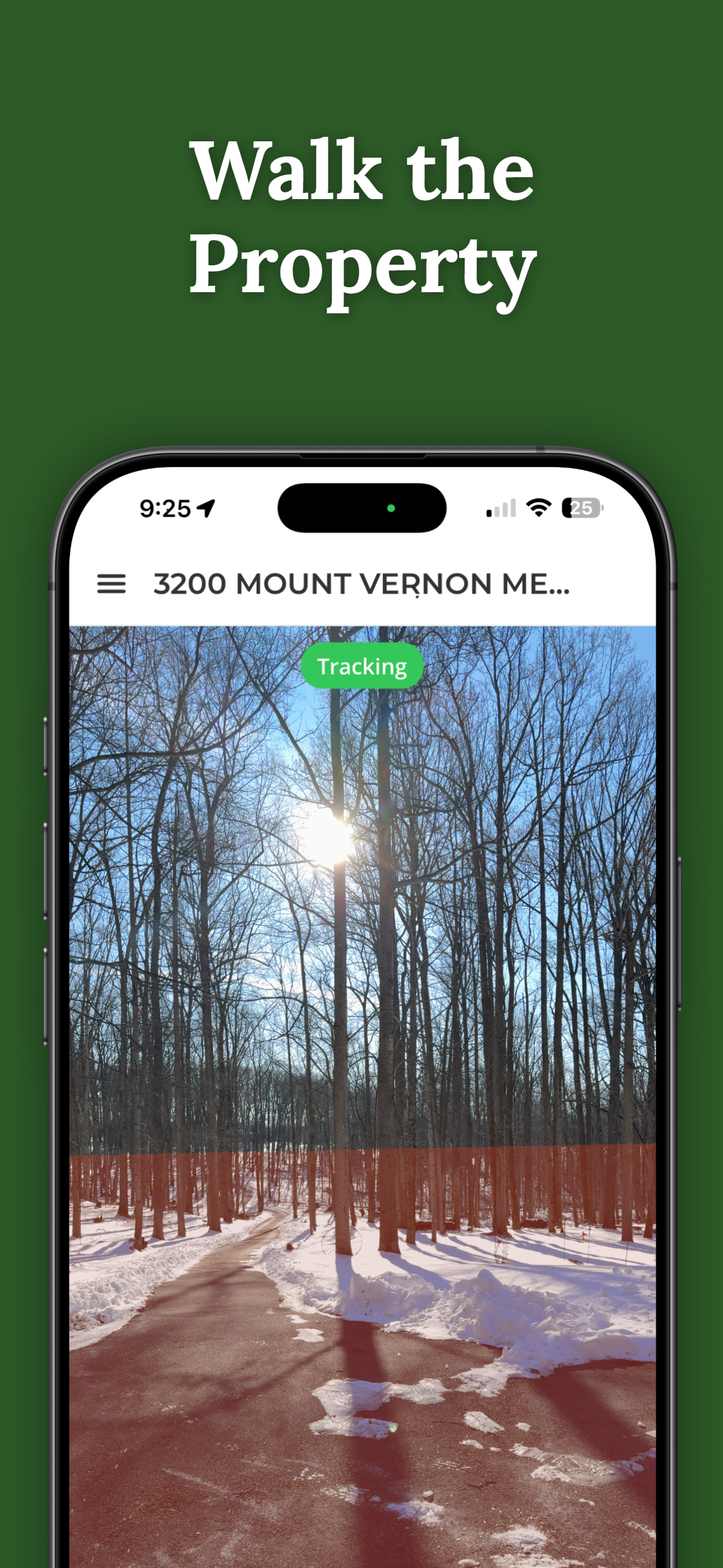
Navigate to Your Boundaries in the Woods
ParcelVision uses AR to show property boundary lines through your phone's camera — even out in the timber. Walk through the trees with a visual guide to where your lines fall. It's a great way to orient yourself before you start the real search for physical markers.
Download ParcelVisionFlagging Tape and Marking Your Lines
As you find markers and trace the boundary, tie strips of bright flagging tape to trees and branches along the line. This lets you see the boundary from a distance — critical in dense woods where you can barely see 30 feet ahead.
Pink, orange, and lime green are the most popular colors. Pick one that pops against the surroundings. But avoid blue, red, or white if those colors were already used for existing boundary blazes in your area — mixing colors creates confusion you don't need.
Flagging tape is temporary. Sun, rain, and wind will break it down within a season or two. If you want something permanent, consider having the line painted. Surveyors and forestry services will paint trees along the boundary at regular intervals using a consistent color. It's one of those jobs that, once done, makes your property lines visible for years.
When to Hire a Surveyor
All of the techniques above can get you in the ballpark, but some situations call for a professional:
- The markers are gone. If the original survey monuments have been destroyed or you simply can't find them, a surveyor can reestablish the corners using the legal description and reference points from neighboring surveys.
- You've got a disagreement. If a neighbor disputes the boundary, only a licensed survey holds up legally. Your own fieldwork won't settle a formal dispute.
- You're about to cut timber or build something. Any construction or commercial activity near the boundary needs to be based on professionally established lines. Guessing isn't an option when money's on the table.
- The boundaries are complicated. Lots of corners, curved lines, or boundaries that follow creeks and ridgelines — these are tough to trace accurately without professional gear.
Surveying wooded land costs more than a suburban lot. Heavy brush, steep terrain, and large acreage all drive the price up. But a professional survey gives you definitive, legally defensible boundaries — and that's worth the investment if you need certainty.
Practical Tips for the Field
You're about to go trudge through the woods with a metal detector and a plat map. A little preparation goes a long way:
- Dress for it. Long pants, sturdy boots, and tick repellent aren't optional. You'll be bushwhacking through brush and kicking through leaf litter. Gaiters are smart if you're in tick country.
- Pack the right tools. Metal detector, compass, a measuring tape or laser rangefinder, flagging tape, a small trowel for digging up pins, and a printed copy of your plat map. A waterproof marker for notes helps too.
- Go in late fall or winter. This is the single best tip. With the leaves down and the undergrowth dormant, visibility through the woods jumps dramatically. Markers and old blazes that are invisible in July become easy to spot in January.
- Bring somebody with you. A second person helps with measuring, holding flagging tape, and — let's be practical — keeping you safe in remote areas. Plus it's more fun.
- Take photos of everything. Snap pictures of every marker, blaze, and boundary feature you find. If your phone tags them with GPS coordinates, even better. You're building a record you can reference later or share with a surveyor.
This article is for informational purposes only and isn't legal advice. Property boundary laws and survey marker regulations vary by state. For legally binding boundary determinations, hire a licensed land surveyor in your area.