ParcelVision
ParcelVision vs onX Maps for Property Boundaries
ParcelVision and onX Maps both show property boundary lines, but they take fundamentally different approaches. ParcelVision uses augmented reality to project boundaries onto the real world through your iPhone camera, while onX overlays boundaries on a traditional 2D map. ParcelVision is a better fit for physically walking and verifying boundary lines on-site, while onX is the stronger choice for comprehensive outdoor navigation with public land layers and trail maps.
Two Different Approaches to Property Lines
If you are a hunter, landowner, or anyone who needs to know where property boundaries fall, you have probably come across both ParcelVision and onX Maps. Both apps can show you property lines, but they solve the problem in very different ways, and understanding that difference is key to choosing the right tool for your situation.
onX Maps is an established outdoor navigation platform that includes property boundary data as one layer among many. It shows parcel lines on a traditional flat map alongside topographic data, public land boundaries, trail networks, and waypoints. It is a comprehensive tool designed for planning and navigating outdoor trips, with property lines as a valuable feature within that larger package.
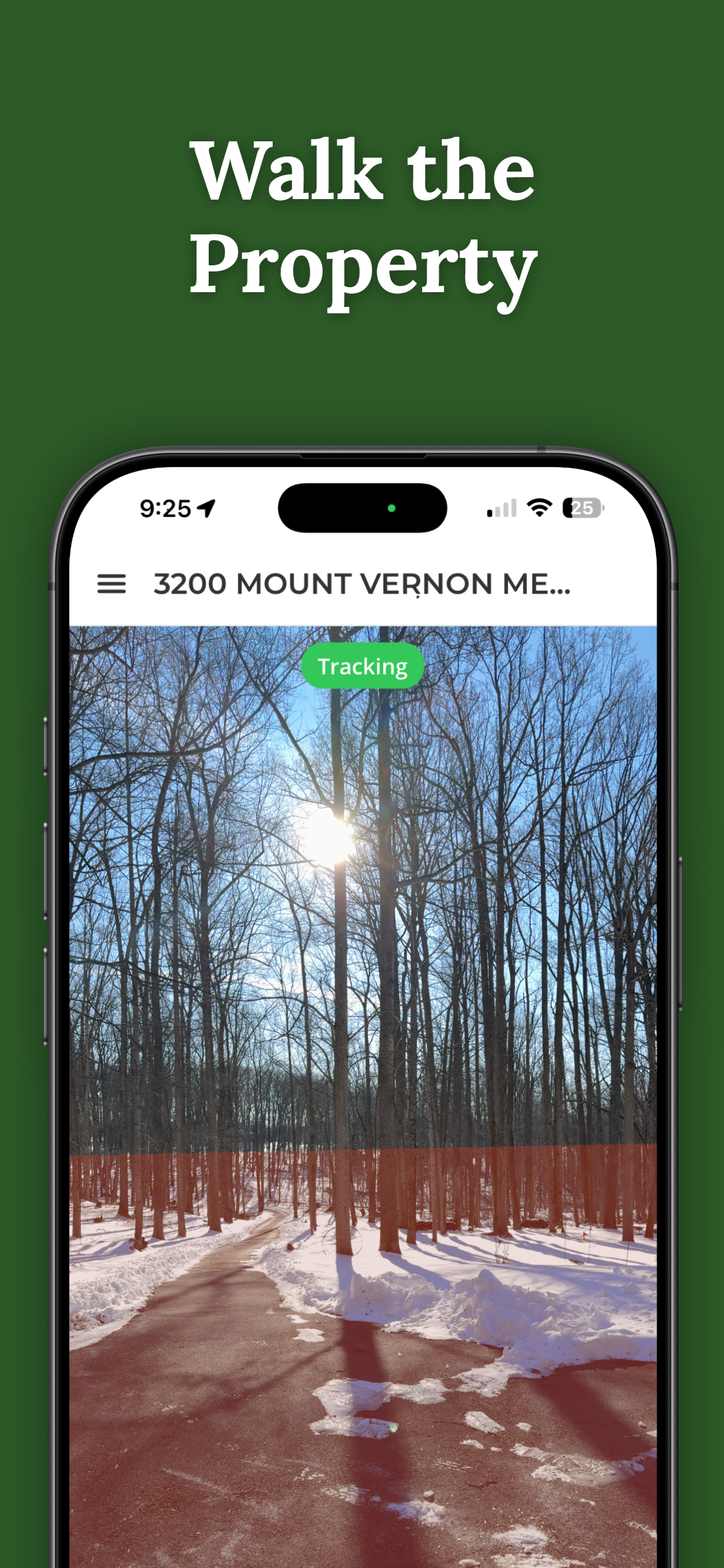
ParcelVision takes a narrower but deeper approach. It focuses specifically on property boundary visualization using augmented reality. Instead of looking at colored lines on a flat map and trying to figure out where those lines correspond to the terrain around you, ParcelVision overlays the boundary directly onto the landscape through your phone's camera. You hold up your iPhone, and the property line appears right there in the real world, anchored to the ground where it actually falls.
The Key Difference: AR vs. 2D Maps
This is the core distinction between the two apps, and it matters more than you might think. With a 2D map overlay, you are constantly translating between two views: the map on your screen and the terrain in front of you. You look at the map, find the boundary line, locate a landmark to orient yourself, and then estimate where the line passes in relation to your physical surroundings. That mental translation works, but it introduces uncertainty, especially in areas without clear landmarks like deep woods or open fields.
With augmented reality, that translation step disappears. You point your phone's camera at the landscape and the boundary line is drawn right on it, following the contour of the land as you see it. When you walk along the boundary, the AR overlay moves with you, showing you in real time whether you are standing on your side of the line or not. It is the difference between reading a description of a room and actually standing in it.
This makes ParcelVision particularly useful when you need to physically verify where a boundary falls, walk a property line with someone else, or show a family member, hunting partner, or potential buyer exactly where the property ends. The visual clarity of AR removes the guesswork.
Feature Comparison
| Feature | ParcelVision | onX Maps |
|---|---|---|
| Boundary Visualization | AR overlay on real world | 2D map overlay |
| Pricing | $14.99 per property, one-time | $29.99/yr (Hunt) or $99.99/yr (Elite) |
| Platform | iOS | iOS, Android, Web |
| Sharing | Share with unlimited people, no extra cost | Individual accounts required |
| Offline Use | Download for offline | Download maps for offline |
| Public Land Layers | No | Yes, extensive |
| Trail Navigation | No | Yes |
| Property Data Source | County parcel records | County parcel records |
Pricing: One-Time Purchase vs. Subscription
The pricing models are fundamentally different. ParcelVision charges $14.99 per property as a one-time purchase. You pay once and have access to that property's boundary data permanently. There is no annual renewal and no recurring fee. If you only need boundaries for one or two properties, the total cost stays low and predictable.
onX Maps uses a subscription model. The Hunt plan costs $29.99 per year and includes property boundaries along with the full suite of hunting and outdoor navigation features. The Elite plan at $99.99 per year adds additional layers and tools. If you stop paying, you lose access to all features.
ParcelVision also has a significant sharing advantage. When you purchase a property in ParcelVision, you can share it with unlimited people at no additional cost. Your hunting group, family members, or anyone else you choose can view the same property boundaries on their own phones without each person needing to buy a separate subscription. With onX, every person in your group needs their own individual account to access the app.
Where onX Maps Is the Better Choice
It is important to be straightforward about where onX Maps excels. If you need more than just property boundaries, onX offers a much broader feature set:
- Trail navigation: onX includes detailed trail maps and GPS navigation for hiking, hunting, and exploring backcountry. ParcelVision does not offer trail navigation.
- Public land layers: onX provides extensive public land data including BLM land, national forests, state trust lands, and walk-in access areas. This is essential for hunters who need to know what land is open for public hunting. ParcelVision does not include public land layers.
- Offline topo maps: onX lets you download detailed topographic maps for offline use in areas without cell service, which is valuable for backcountry trips. ParcelVision supports offline use for property data but does not include topo maps.
- Platform availability: onX is available on iOS, Android, and the web. ParcelVision is currently iOS only.
If your needs go beyond property boundaries into general outdoor navigation, public land identification, and trip planning, onX Maps is designed for that broader use case.
When to Use ParcelVision
ParcelVision is the stronger choice when your primary need is understanding where property boundaries actually fall on the ground:
- Walking property lines physically: The AR overlay lets you follow the boundary in real time as you walk it, without switching between a map and the terrain around you.
- Showing boundaries to others on-site: When you need to show a family member, hunting partner, neighbor, or buyer where the property line runs, pointing a camera at the landscape and letting them see the line is far more effective than handing them a map.
- One-time purchase per property: If you only need boundaries for specific properties, the one-time pricing is more cost-effective than an annual subscription.
- Sharing with your group: A single purchase shared with your entire hunting group, family, or team eliminates the cost of multiple subscriptions.
See Boundaries in the Real World
ParcelVision uses augmented reality to project property lines directly onto the landscape through your iPhone camera. Instead of matching a 2D map to your surroundings, you can see exactly where the boundary falls as you walk it.
Download on the App StoreUsing Both Apps Together
Many hunters and landowners find that the two apps complement each other well. You can use onX Maps for the planning phase: scouting public land, marking waypoints, planning your route, and navigating trails to your destination. Then, when you arrive at a property and need to verify where the boundary falls in the real world, switch to ParcelVision for the on-the-ground AR visualization.
This combination gives you the best of both approaches: onX's comprehensive outdoor mapping for the big picture and ParcelVision's AR precision for the specific moments when you need to see exactly where a property line runs across the landscape in front of you.
This comparison is for informational purposes only. Feature details and pricing are based on publicly available information and may change. ParcelVision is not affiliated with onX Maps.